Thursday, July 30, 2009

Garbage Miners Leave Big Hole


Treasure hunters leave big mess just south of Chester Springs Marsh

An alert from a fellow Don Watcher led me to investigate an area near Chester Springs Marsh, one of the Task Force's earliest restoration sites. When I arrived on site, I was surprised to find an area about 5x10m strewn with rubble and debris. In the centre of this mess is an impressive hole about 4m deep. At the bottom of the hole a shovel is visible. Although well off the path, the hole would be difficult to climb out of even for a tall guy like me.

It's a well known fact that this area is was a former dump from the days of the Don Valley before organized municipal garbage collection. Chester Springs Marsh has had treasure seekers digging before and signs have been posted warning that such activities are illegal. I suppose the diggers took advantage of the civic worker's strike and did their excavations when there were fewer eyes to keep watch over the site.

The site is a hazard and will be expensive to cleanup. I find it ironic that during a time when the Don is once again the repository for new dumps that somebody would take it upon themselves to remove some garbage.


4 metre deep hole is pretty impressive. Warning: don't get too close because the sides of the hole at the bottom are collapsing.


Discarded bottles and other detritus litter the area. I wonder if they found anything valuable?

Tuesday, July 28, 2009

The Power of Water


Damaged bridge in Wilket Creek Park

The storm from this past weekend was strong enough to severely damage a pedestrian footbridge in Wilket Creek Park. Just south of Edwards Gardens, the storm water washed away the stone and gravel from around the footings of the bridge. The bridge is anchored by 4 steel pillars and that is all that is left standing. The power of the water flow is evident in how the armour stones placed along the stream banks were knocked around like pebbles.


All but the bridge footings have been washed away


2 tonne armour stone blocks tossed around like pebbles


A similar bridge just downstream shows where the armour stone is supposed to be

This type of storm damage now occurs about once a year. About a year ago, a similar storm caused similar damage to bridges in this ravine. Fortunately the bridge is well anchored so it's only a matter of reconnecting the bridge to the path to fix it up. However, problems like this are likely to reoccur until the underlying problem of too much stormwater runoff is resolved.

Thursday, July 23, 2009

City Strike Means More Dumps in the Don


Cars queue up to unload garbage bags in Wilket Creek Park

As the civic workers' strike grinds into its second month, the garbage at temporary dumps is starting to pile higher and deeper (doesn't take a PhD to figure that out ;).

Already a few temporary dumps have filled up and have closed which means more have opened up to replace them. One of these is at Leslie and Eglinton on the West Don in Wilket Creek Park. Unfortunately for the Don, the conditions imposed on the city by the Ministry of the Environment on where temporary dumps can be sited means that many parking lots in the valley are ripe for the taking. Coupled with the fact that these places are relatively far from residential areas and are partially hidden by the ravine depth and surrounding trees make the Don an ideal place to unload our waste.

The Wilket Creek site is the second dump setup in the Don but if the strike goes on much longer it won't be the last. Other places that I can think of where the city could setup dumps are:
  • Earl Bales Park
  • Serena Gundy Park ( adjacent to Wilket Creek)
  • Taylor Creek Park (at Dawes Road)
  • Warden Woods (off Pharmacy Ave)
  • Sunnybrook Park (two large parking lots)
  • Milne Hollow (Lawrence Ave East at the DVP)
  • G. Ross Lord Park
The Don Valley has had a long history of being a dumping ground for our waste. Before garbage pickup was taken over by Metro in the late 1960's, the Don was home to about 30 legal garbage dumps. They have all been closed but that garbage still remains. I won't get into the stuff that still ends up in the river today.

There have been a couple of high profile protests at neighbourhood parks but you are unlikely to see anything similar at park sites. Unless the trees decide to start walking and blocking roads, the Don (and other ravines) will be the unfortunate recipients of our garbage.

Friday, July 17, 2009

Wicking Water

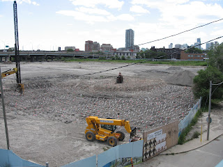
Just south of the Queen Street bridge some odd looking construction is occurring. There appears to be a forest of silver ribbons poking out of the ground. What are they doing? This technique is called wicking and it is used to remove moisture from the ground.

This area is the northwest corner of the future Don River Park and the western portion is being anchored by what is officially known as a "flood protection landform". This is a kind of levee or berm and is meant to protect the West Don Lands from serious flooding on the order of a Hurricane Hazel size storm. The construction of the berm requires that a large amount of earth be piled in one place. Before that can be done, the ground beneath it must be dried out and compacted. The easiest way to dry out the ground is to insert these silver coloured plastic strips into the ground. Using capillary action, the water in the soil travels to the surface where it evaporates into the air. Once the soil is dried out sufficiently then the new soil can be placed on top. Dry soil compacts easier and has less chance of shifting or moving later on, which is something you don't want to happen for a device that is meant to hold back large amounts of water.


Ribbon forest

Silver coloured wicking strips

The berm is expected to be completed sometime this fall. Once complete, construction of the park and the new neighbourhood to the west can commence.

Monday, July 13, 2009

Wetland Watching

It was such a nice day on Sunday I decided to go on a bicycle trip in the ravines. An unintended consequence of the civic worker's strike is that the fields of grass are no longer mowed. As soon as I entered the ravine, I was pleasantly surprised by the fragrant fields of clover that now cover the grass. Maybe once the strike is over we can get Parks to mow less often. It will be cheaper and produce more flowers. The parks will smell better and the bees will be very happy!

One of the places I stopped at was the Goulding wetland. At the pond, the water level was lower but that was to be expected. The water source for this pond is solely from ground water so as it fluctuates, so does the pond. This is normal for a wetland of this type and many of the plant species that are found along the shoreline are adapted to these conditions.

Along with the plants I spotted a couple of mallard ducks as well as the usual coterie of butterflies, dragonflies, water striders and other assorted insects.


Goulding Wetland


Another view of the wetland

A pair of Mallard Ducks (Anas platyrhynchos) forage for food along the pond edge.

I also visited my old stomping grounds at the Beechwood Wetland. I saw some frogs and turtles there which is a good sign of a healthy pond.


Beechwood wetland

A Green Frog (Rana clamitans) at the water's edge resting in a pile of what looks like raccoon crap. Scatologists: eat your heart out!

I noticed a turtle lurking just below this lily pad. This is the first turtle I've ever seen at Beechwood. I couldn't tell the species but I think it's a Painted Turtle (Chrymemus picta picta).

A single Purple Loosestrife (Lythrum salicaria) was growing at the water's edge.


Not far from the pond a cluster of Fringed Loosestrife (Lysimachia ciliata) was growing. This plant shares the name with the purple flowering plant but is in fact in a different family. Also this one is native while Purple Loosestrife is a non-native exotic.

Sunday, July 12, 2009

Hike in Taylor Creek Park

On Sunday July 5, I led my 3rd of 6 hikes for the summer. It was a warm sunny day and 52 people showed up. The route I chose went from the Victoria Park Subway Station and went through Taylor Creek Park to the Don River. I then led the hike along a biking trail known as "The Flats". The hike ended at Pottery Road and Broadview. After the hike a number of hikers went for a beverage (or two) at Whistler's Bar and Grill.

My next hike is scheduled for Sunday July 19, 1 PM, starting at Overlea Blvd and Thorncliffe Park Drive (east). It will head down the Don ending up at the Distillery District.


Map of the hike. I prepared this map for a hiker who wanted to know where the best drop out points were. These are marked on the map.


Getting started in Taylor Creek Park


Walking by the garbage dump in Stan Wadlow Park


Making our way along a trail in the woods


Climbing over a trail obstacle


A forest setting

I led the hike by the Elevated Wetlands. We got to walk underneath a waterfall!

Friday, July 10, 2009

Garbage in the Don

I've been active in the Don Valley for several years removing garbage from natural areas. Now it appears that the city is putting it right back. The Don is now the dubious host for a number of temporary city dumps, courtesy of the ongoing civic workers strike. The first one was setup next to Taylor-Massey Creek in the parking lot at the foot of Stan Wadlow Park.


The dump

The garbage pile

I have also heard that another site is opening soon in Wilket Creek Park near Leslie and Eglinton. In addition to the legal sites there are now a few examples of illegal dumping. If the civic workers strike lasts much longer I am sure we will see more of these.


Illegal dump near Pottery Road

Another dump next to Pottery Road

This looks more like homeless garbage but is still an illegal dump. Found next to Lower Don Trail just north of Bloor Street Bridge.

Wednesday, July 08, 2009

Laying Track

I happened by the Queen St. bridge over the Don last Saturday and noticed some activity on the railway tracks that parallel the river. Workers had removed some track underneath the Eastern Ave/Front St. bridge and were replacing it. They were also replacing a switch (see track in foreground) but I couldn't stay for that part. I took these photos before going on my way home.


Construction scene

Closeup of same

Putting the new track in place

More track action.

Friday, July 03, 2009

Relocated Buildings

Previously I have blogged about two building in the Don that have recently been moved. Here are some photos of the final resting places.


St. Matthews lawn bowling club. Moved from Gerrard St. East to Broadview Ave.


The Don Station. Moved from Todmorden Mills to the up and coming railway museum at the John Street Roundhouse. The Toronto Railway Historical Association has an interesting blog about activities underway at the roundhouse.